News in 2025

|
Geo-SEE leads international push for a Modern State Plane Coordinate
System in North Macedonia
31 October 2025, Skopje, North Macedonia

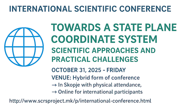
The international scientific conference themed "Towards a State Plane
Coordinate System: Scientific Approaches and Practical Challenges", held
in hybrid format on October 31, 2025, in collaboration with 8 esteemed
international organizations and companies.
|
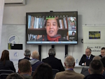
FIG President Dr. Diane Dumashie,
United Kingdom, participated in the opening ceremony with an
address thanking the organisers for their vivid engagement in
this special hybrid conference.
|
At Mother Teresa University in Skopje, North Macedonia, participants
from leading regional cartographic associations and international
experts gathered to address the critical establishment of a cutting-edge
State Plane Coordinate Reference System (SPCRS) for North Macedonia.
Organized by the South-East European Research Institute on Geo Sciences
(Geo-SEE Institute), the conference focused on crucial themes such as
existing Common Reporting Standard (CRS) practices, legal frameworks,
and implementation challenges.
The Geo-SEE Institute, as the main organizer and under the umbrella of
the International Federation of Surveyors (FIG), was strongly supported
by the Bulgarian Cartographic Association, the Croatian Cartographic
Society, the Kosovo Association of Surveyors, the European Group of
Surveyors, and the Macedonian Chamber of Trade Surveying Companies as
co-organizers. The event was sponsored by the Alb Matrix Group (Geo
Sensors) from Albania and the company FARO Europe.
FIG President Dr.
Diane Dumashie, United Kingdom, participated in the
opening ceremony with an address thanking the organisers for their vivid
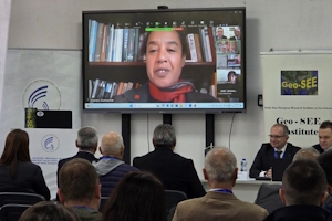
engagement in this special conference. Honorary President of FIG,
Chryssy Potsiou, Greece, took active part in the entire
conference virtually.
Facilitating vital
knowledge exchange
The primary objective of the conference was to present the key results
of the national project SCRS Project (National Scientific Project: State
Plane Coordinate Reference System - Republic of North Macedonia), engage international experts, share
experiences, discuss methodologies and findings, and explore the future
implementation of the proposed coordinate reference system (CRS) for
North Macedonia.
Distinguished presenters from North Macedonia, Albania, Bulgaria,
Croatia, Germany, Greece, Kosovo, the Netherlands, and Türkiye shared
their scientific findings and practical experiences related to state
plane coordinate reference systems. The hybrid event attracted a diverse
range of participants, including experts, researchers, and institutions
working towards harmonizing national geospatial systems with European
standards. In total, 67 participants attended the conference in person
and 91 joined online, demonstrating strong regional and international
engagement in this important field.
Key outcomes underscored the urgent need for a legally compliant CRS
that aligns with European standards (ETRS89/GRS80)*, robust stakeholder
engagement, and a clear transition from research to actionable
implementation. The conference not only facilitated vital knowledge
exchange but also laid a strong foundation for ongoing collaboration to
enhance national geospatial systems, with effective dissemination
strategies set to amplify its impactful findings through publications
and digital platforms.
The international scientific conference on the state-plane coordinate
system marked a key step in advancing the theory of state-plane
coordinate systems and map projections for large-scale mapping. By
bringing together science, practice, and policy, the event strengthened
the foundation for a modern national CRS that will benefit geospatial
applications, environmental monitoring, surveying, topographic mapping,
cadastre, civil engineering, Geographic Information System (GIS), and
all national-level activities related to geospatial data and
information. For practitioners and researchers, this development offers
a timely opportunity to align projects and data infrastructures with
evolving national standards, enhance data interoperability, and
strengthen the scientific quality of analyses.
Read the full report here
Conference website
*ETRS89: European Terrestrial Reference System 1989. GRS80: Geodetic
Reference System 1980.
Bashkim Idrizi, Chair, North Macedonia
Lyubka Pashova, Co-chair, Bulgaria
Published 24 November 2025