|
The unveiling of the plaque by Colin Bollaert-Davies, President
of the Institute of Professional Land Surveyors of the Eastern Cape |
The Arc of the 30th Meridian is known to
surveyors worldwide as a triangulation system that stretches from South
Africa northwards all the way to Cairo. On 8 June 2004 a plaque was
unveiled on the southern terminal beacon at Buffelfontein in the Eastern
Cape of South Africa to commemorate the 125th anniversary of when the
idea of such an Arc was conceived and the 50th of its completion.
It was the idea of David Gill when he arrived in South Africa as
Her Majesty's Astronomer at the Cape of Good Hope in 1879.
Among his very first actions was to pursue with the Governor and others
the thought of a Cape to Cairo Arc. Within a matter of just a few years work
was under way and by 1910 had been completed to about 9º South. After slow
and piecemeal progress by 1950 the whole arc had been completed except for a
1000 km in Northern Uganda/Southern Sudan where the Sudd area was a barrier
to traditional survey methods. In 1953-4 the US Army Map Service arrived in
force and closed the gap. This was soon followed by the US Air Force, who in
1954 in cooperation with the Greek Army Geographical Service and the Survey
of Egypt, observed a Hiran connection from North Africa (Egypt and Libya) to
Crete across the Mediterranean Sea. |
Thus it was that part of Gill's "Dream" came into being after 75 years of
survey work. However by 1900 Gill had extended his original dream to the
idea of an Arc from "Cape to Cape" meaning Cape Colony to North Cape in
Norway. Evidence suggests that although not in way thought of by Gill, the
extension of the Arc from Crete to North Cape can be proved through work
carried out at several different periods from 1816 to 1855 and in the period
between the Great Wars.
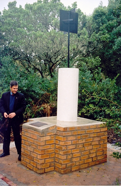
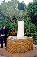
The beacon at Buffelsfontein witnessed a group of surveyors gathered in
showery weather in a most picturesque area outside of Port Elizabeth to
watch Colin Bollaert-Davies, the President of the Institute of
Professional Land Surveyors of the Eastern Cape, unveil the plaque on a
refurbished beacon of the Geodetic Survey of South Africa. It is the hope of
the local surveyors that it will prove possible for the beacon to be
recognised as a national monument since there are precedents for such in the
Cape Town area.
Any readers, particularly in the countries through which the arc goes,
who are interested in the 30th Arc are welcome to contact Jim Smith at
jimsmith1780@gmail.com.
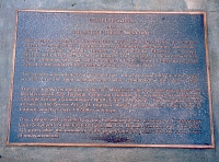
The plaque. The text on the plaque is as follows:
"BUFFELSFONTEIN and THE ARC OF THE 30th MERIDIAN
This beacon represents the Southern most point of a chain of triangles
Measured along the 30th meridian through Botswana, Mozambique, Zimbabwe,
Zambia, Tanzania, Burundi, Uganda, the Democratic Republic of Congo, Sudan
and ending near Cairo in Egypt. The purpose of the measurement was to
determine the size and shape of the Earth. Prior to 1999 the beacon was also
the origin of the geodetic survey of South Africa.
The project was initiated by Sir David Gill, the Astronomer Royal at the
Cape in 1879 and the final measurements were completed in the Sudan 1954.
The arc, known as the Arc of the 30th Meridian, can be connected across the
Mediterranean Sea through Crete and Belarus to a similar arc measured
through Europe terminating at North Cape in Norway. The European arc is
known as the Struve Arc and together these two arcs cover nearly 105º in
latitude which is over 11650 Km in length.
This plaque was unveiled by the President of the Institute of Professional
Land Surveyors of the Eastern Cape, Mr C J Bollaert-Davies, on 8 June 2004,
125 years after the initiation of the project and 50 years after the
completion of measurements.
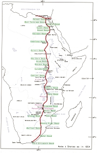
Map of the whole of the 30th Arc. Reproduced courtesy of
T. Zakiewicz